P6 — Visual Localization
Visual Localization and Navigation Using AprilTags
This project implements a vision-based localization and navigation system for a mobile robot using AprilTags as known references.
The robot continuously detects visual markers, estimates its global pose from the camera, and autonomously navigates towards them while avoiding frontal obstacles.
The system combines camera geometry, pose estimation, reactive control, and landmark-based localization, without relying on odometry or mapping.
General Strategy
The robot follows a main loop that integrates:
- AprilTag detection using the onboard camera
- Absolute pose estimation using known tag positions
- Reactive obstacle avoidance using laser data
- Navigation directed toward detected tags
- Memory of visited landmarks
If no valid visual references are available, the robot performs a controlled rotation to recover localization.
AprilTag Map
Tag positions are defined a priori in a YAML file, each with:
(x, y, z)positionyaworientation
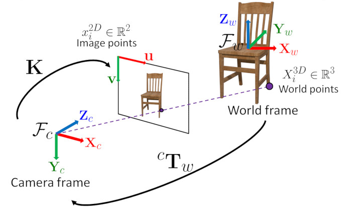
These data are transformed into 4x4 homogeneous matrices, allowing direct transformations between the tag frame, the camera, and the world, establishing a global reference system.
Camera Model and Tag Geometry
The camera is modeled as a pinhole projection:
- Square focal length proportional to the image width
- Principal point at the center
- No lens distortion
Each tag is defined as a square with known dimensions and its four local 3D points are stored, allowing pose estimation from a single image.
Visual Pose Estimation
For each detected tag:
- Extract the corners from the image
- Apply
solvePnPto obtain the camera→tag transformation - Invert it to get tag→camera
- Select the nearest tag to reduce noise
- Compute the chain of transformations to the world
From this, we obtain:
- Global pose
(x, y) yaworientation of the camera’s forward axis
This provides an absolute pose estimate, independent of prior state.
Reference Frame Alignment
Fixed rotations are applied to align:
- Camera forward direction
- Horizontal world plane
- Extracted yaw angle
This ensures a consistent geometric interpretation of position and orientation.
Reactive Obstacle Avoidance
The frontal sector is continuously monitored with the laser:
- If a nearby obstacle is detected
- And no tags are visible
The robot stops linear motion and rotates in place. The rotation direction depends on the obstacle location, enabling safe exploration while searching for visual references.
Landmark Selection
To avoid oscillations:
- Detected tags are filtered using a memory of visited ones
- Unvisited tags are prioritized
- When approaching a tag, it is marked as visited
- After each visit, the rotation direction can be reversed to improve coverage
Motion Control
A proportional controller is used toward the selected tag:
- Linear velocity proportional to distance
- Angular velocity proportional to orientation error
- Commands are saturated to ensure smooth motion
If no valid pose estimate exists, the robot adopts cautious movement or a recovery rotation.
Pose Propagation
When no visual update is available, the estimated pose is propagated using differential kinematics.
Angular velocity is scaled to compensate for actuator mismatches, improving temporal consistency.
Videos
Non-Inverter
Inverter
Conclusion
This project demonstrates a complete landmark-based visual localization system:
- Absolute pose estimation from tags
- Robust recovery from reference loss
- Reactive obstacle avoidance
- Simple and effective navigation
- Lightweight, modular, and suitable for indoor environments with visual markers